
2.2 Infrastructure
For development to proceed within the town, it will be necessary for development proposals to address the effects imposed on existing water services (water supply, foul drainage and storm drainage systems). During the period of the last plan, a new wastewater treatment plant was provided in Gowran.
2.2.1 Water Services
2.2.1.1 Wastewater System
Gowran is served by a public wastewater collection system and associated treatment plant that provides full secondary treatment with nutrient (nitrogen and phosphorus) reduction, produces treated effluent to the standards set out in the Urban Wastewater Treatment Regulations, and finally discharges to the River Gowran (Mill Stream) which flows adjacent to the plant.
The treatment plant is designed to treat a wastewater load equivalent to that which would arise from a population of 1,600 persons (the Population Equivalent, or “PE”, Design Loading); this loading includes both the domestic sewage plus the commercial-industrial wastewater arising in Gowran which is anticipated within the design lifetime of the plant.
The plant is designed so that both the actual load capacity of the plant and the quality of the treated effluent discharged to the adjoining River can be relatively easily improved and upgraded if further population growth occurs and should more stringent standards be applied in the future to treated wastewater discharged to the environment.
Most of the development in the town is connected to the public system, however a number of houses on the Kilkenny Road operate from individual septic tanks.
Policies & Objectives: (Chapter 9 of the County Development Plan 2008-2014 also applies)
Obj. IN1 To provide full treatment to all of the wastewater from Gowran to the standard required in the relevant environmental legislation
Obj. IN2 To extend the area covered by the wastewater treatment network to serve existing development within the development boundary, as resources and finances permit
Policy IN3 To preserve free from development, the way leaves of all public sewers
2.2.1.2 Water supply
Gowran is served by a large regional scheme, namely the ‘Gowran – Goresbridge – Paulstown Water Scheme’. There is no spare capacity within the scheme. The system serves an existing population of 1,900 approximately.
At present, water supply volumes in the scheme are inadequate to meet any further development. Kilkenny County Council proposes to augment and upgrade the existing scheme, subject to resources.
The scheme has experienced some intermittent problems with bacterial contamination of the source, which is located east of Paulstown, at Tobergoolick pool. A report on The Provision and Quality of Drinking Water in Ireland – A Report for the Years 2007-2008 (Office of Environment Enforcement EPA, 2009) found that there was one incident of E. coli contamination in public water supplies in the Gowran-Goresbridge-Paulstown supply during 2007. Proposals have been drawn up for improving the treatment to combat bacterial contamination at the source and these will be implemented during the lifetime of the Plan.
Water conservation measures will be encouraged in the plan area.
Policy IN4 Significant additional development will not be permitted to connect to the public water supply until such time as the Water Scheme is upgraded
Policy IN5 To preserve free from development the way leaves of all public water mains
Policy IN6 To encourage the adoption of water saving measures throughout future development. Such measures would include: water butts, low flush and dual flush toilets, low water use appliances, rainwater harvesting, greywater recycling
Obj. IN7 To install an advanced treatment to combat ongoing intermittent bacterial contamination of the source
Obj. IN8 To upgrade the Gowran–Goresbridge–Paulstown Water Scheme, subject to resources
2.2.2 Flood Risk Assessment
In line with the Guidelines for Planning Authorities on The Planning System and Flood Risk Management (2009), a staged approach has been adopted to the appraisal and assessment of flood risk.
Stage 1 – Flood Risk Identification
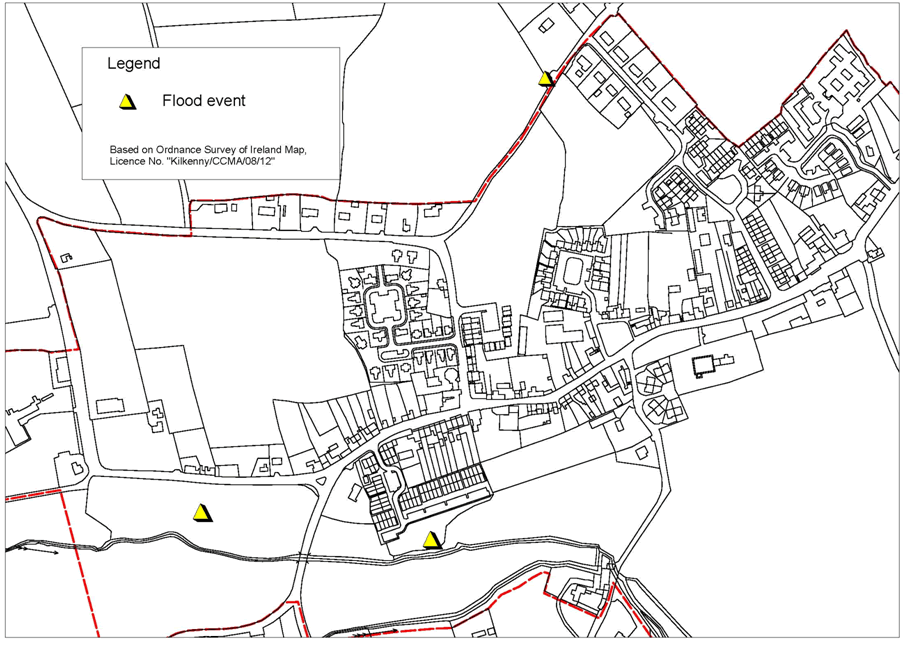
Stage 1 of this appraisal is Flood Risk Identification which includes a review of existing information and identifies if there are any flooding or surface water management issues in the plan area which may warrant further investigation. A review of existing Office of Public Works (OPW) and local information was carried out. According to the OPW National Flood Hazard Mapping, there are no recorded flood events within a 2.5 km radius of Gowran. From local information, three sites which have experienced flooding have been identified. These are shown on Figure 2.1. The first is the field north of the river which contains the Bastionfort well. This site forms part of the floodplain of the river and the Ordnance Survey six inch map (2nd edition) of the area indicates that it is liable to flooding.
The Flood Risk Management Guidelines recommend a Sequential Approach for taking account of flood risk. The sequential approach works by guiding development away from areas that have been identified through a flood risk assessment as being at risk from flooding. In accordance with this approach, this site is zoned for Agriculture. In this regard, the avoidance principle of the sequential approach has been met.
Two other locations which have experienced flooding are the Bradóg Way housing development and also on the Rockfield Road to the north of the town. At Rockfield, flooding occurs on the road at the soccer pitch entrance. This occurs when the amount of rainfall exceeds the infiltration capacity of the ground to absorb it. This excess water flows overland and ponds in the lowest point in the road.
At Bradóg Way, the Ordnance Survey six inch map (2nd edition) of the area indicates that the strip of land closest to the river forms part of the floodplain and was liable to flooding. The issue of flooding was examined during the planning application process for Bradóg Way and the finished floor levels of the houses nearest the river were set to a level where it was unlikely that flooding would affect.
Flooding has occurred on the site on the hard surfaced parking/road area, nearest the river, and also in the front gardens of the houses facing the river. There has also been flooding in some of the back gardens.
As these two areas lie within the development boundary, and could be potentially affected by development taking place under this LAP, the process will move onto Stage 2.
Stage 2 – Initial Flood Risk Assessment (FRA)
The purpose of the initial FRA is to ensure that all relevant flood risk issues are assessed in relation to the decisions to be made. It also ensures that potential conflicts between flood risk and development are addressed to the appropriate level of detail.
At Rockfield, the ponding of water on the road can be addressed through carrying out improvement works under the Roadworks programme. This will be carried out in such a manner to ensure that ponding does not occur.
A preliminary examination of the flooding at Bradóg Way was been carried out and the indication is that it is caused by a lack of capacity in the existing storm water pipeline running through the estate to the river. It will be necessary to ensure that no additional surface water is channelled through the storm water system here. The issue of flooding at Bradóg Way will be investigated, and appropriate remedies will be pursued by the Council. Addressing the surface water capacity issues, and ensuring no additional surface water enters the network, will prevent the recurrence of flooding.
As mitigation measures have been identified to ensure firstly that any development taking place will not exacerbate the existing problems and secondly which will prevent the recurrence of flooding, it is not considered necessary to proceed to Stage 3, Detailed Flood Risk Assessment.
Areas of wetland provide storage for flood waters and can reduce flood risk elsewhere. An area of wet woodland lies along the river to the south of the town, and this was identified in the 2003 Plan and in the Habitats Assessment carried out for this plan, as being of ecological value. This important area will be protected firstly, through zoning it for open space and also by the inclusion of specific policies as outlined in Section 2.7 Natural Heritage.
Policy IN9 To maintain the River Gowran free from inappropriate development and to discourage its culverting or realignment
Policy IN10 To ensure that no additional surface water drainage is permitted through the existing pipeline running through Bradóg Way
Obj. IN11 To address the flooding at Rockfield through the Roadworks programme
Obj. IN12 To address the flooding issues at Bradóg Way and to pursue appropriate remedies, to prevent the recurrence of flooding

Figure 2.1 Recorded Flood events Source: Local knowledge
2.2.2.1 Surface Water Drainage
The County Development Plan requires a separation of the surface water system from the foul drainage system. There is a separate surface water drainage system in Gowran, which runs along Main Street through Bradóg Way to an outfall into the Gowran River. An additional outfall to this system is currently being examined.
In accordance with the County Development Plan, the use of Sustainable Drainage Systems (SuDS) will be encouraged in the plan area.
Policy IN13 To require a separate surface water drainage system from the foul drainage system, for all cases where surface water drainage measures are required and to consider all drainage proposals consistent with SuDS
2.2.3 Waste
The current Joint Waste Management Plan for the South East Region (JWMP) sets out the policies and objectives for waste management for the period 2006 to 2011.
There is a bring centre in Gowran at present, located beside the Community Hall, where glass (brown, green, clear) and aluminium cans can be deposited. This is considered an appropriate location for a bring centre.
The importance of education and awareness in the encouragement of recycling and promoting more sustainable practices is acknowledged by Kilkenny County Council and endorsed by the appointment of an Environmental Awareness Officer in 2002. This Officer provides regular dissemination of information through group meetings, leaflets and other promotional materials, and any community can access these services. These services will continue to improve the level of environmental awareness throughout the county.
2.2.4 Telecommunications
Telecommunications have become centrally important to the prospects of any local economy. Broadband is available in the Gowran area through mobile, satellite and Digital Subscriber Line (DSL) providers.
Policy IN14 To support and encourage the provision of the necessary telecommunications for the existing and future development of Gowran
Policy IN15 To ensure development proposals include the provision of ducting for fibre based data services and in particular broadband services, as appropriate.